|
|
|
|
Speak’s Quarry |
|
|
|
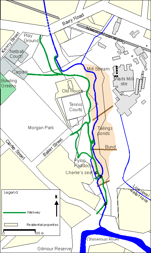
Mill Stream Walkway Historic Features
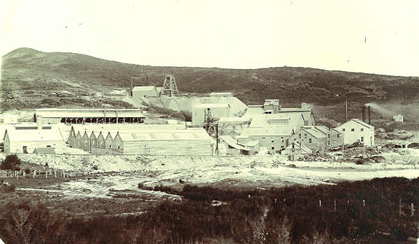
The Speak family lived on Barry Road adjacent to the present Newmont conveyor, and in close proximity to the quarry. Mrs Speak is variously recorded in the Ohinemuri Regional History Journals as running a fruit shop and/or a sweet shop. The quarry was named after this family. The quarry may have been owned/operated by the Waihi Gold Mining Company. The Waihi Battery was built in 1888. It appears that the earliest machine mounts were constructed of masonry. A convenient place to quarry this would be what we now call Speak’s Quarry, though no literature confirms this, and it does not appear on any early maps. If before quarrying, Speak’s was an outcropping of stone, ie well above the level of Mill Stream at the "reservoir", and accessed directly from Barry Road, then the early quarry could co-exist with the early water races. Otherwise, the configuration (including access road) that appears in the c.1906 photograph (and through to today), would conflict with the Mill Race. If the 1893 map has mistakenly suggested an early Mill Race, then this removes most of the perceived conflict. Perhaps Speak’s Quarry did not exist until 1906, and this piece from the Annual Report from the Directors, for the year 1906, was indeed the start of the quarry: A small " special site " of half-an-acre for a quarry near Waihi Mill was taken up. Or were they legitimising an existing usage? If not from Speak’s, then where could the stone for the Mill have been sourced? This same map shows a road coming from direction of the modern end of Clarke Street to the Waihi Mill site. No Clarke Street is shown. This is the road that gave the name "road level" to the Amaranth adit. McAra, p97, of 1895: a new road level drive to be put in from the roadway at the western end of the Amaranth reef. The purpose of this road is unknown, but it could have facilitated transport of stone. A January 1941 "Schedule of Titles and Deeds" mentions Special Site 21, a quarry on Winner Hill. No clear answer. The only map to show Speak’s Quarry was drawn 1923, and places it at the north eastern corner of the Battery Manager’s house property. Ernie Thomson related that the floor of the stables was made from cobbles probably from this quarry. He lifted these and used them around his property, No.46 Barry Rd.
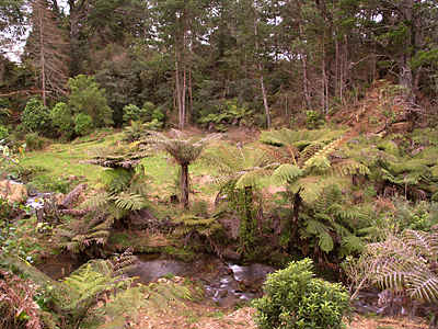
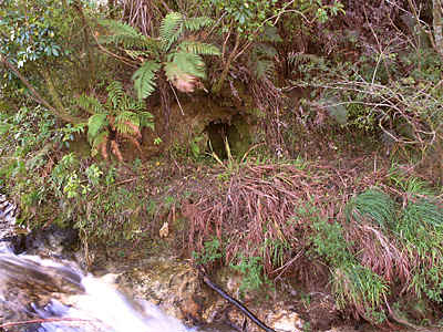
Speak’s Quarry Explosives MagazineImmediately downstream from the quarry, on the true left bank of the stream, a very short tunnel is carved into the bank. Debris from the river has reduced its height. This could have been the explosives magazine (store) for the quarry.
|
|
Waihi District Walkways Inc. PO Box 241 Waihi New Zealand Send e- mail to: Waihi Walkways |