|
|
|
|
Drain West of Charlie's Seat |
|
|
|
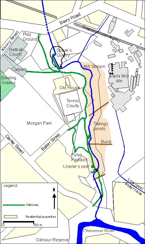
Mill Stream Walkway Historic Features
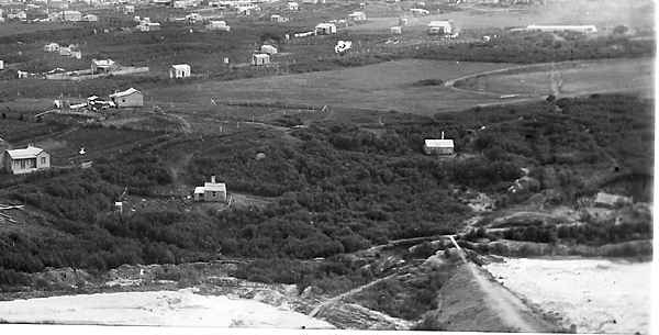
Below is a portion of an early photograph, looking over the middle tailings bund, with what will be Baker Street and Morgan Park in the distance. The scene includes the area where the Cassel Tailings plant water race would be, so as they are not present, the photograph must be earlier than March 1894 (when they started work on the tailings). The St. John's Church can be seen in the uncropped photograph, it was built in 1894 (Diamond Jubilee Booklet). Careful study of the photograph is rewarding. The tailings bund is the one opposite our Pylon Paddock. The lower tailings pond is now our Cabbage Tree Flat, and the ditch running horizontally behind it is the water filled ditch behind Charlie’s seat. At the end of the bund a plank gives walking access across two deep cuttings. The first allows tailings and water through the bund, into the small wooden flume and thence into the lower tailings pond. The next cutting allows water from the cut-off drain above the tailings to pass through the bund, and continue on to the ditch mentioned above. The cut-off drain will be discussed more fully in Cut-off Drains. Several walking tracks are visible, and indeed Baker Street appears to be no more than a track at this time. A path traverses the bund, and after the plank joins a track running more or less horizontally across the picture. Access to the battery from the west would probably have been restricted to the bunds, as crossing the unconsolidated tailings would have been hazardous. My interpretation is that this horizontal track approximates our current walkway in this area. The first cutting crossed by the plank is now where the stream runs in its narrow cutting through the bund, though presumably deepened when Mill Stream was redirected through it. The second cutting is where the walkway passes through the bund, with associated earth filled steps. If the drain behind Charlie’s seat was part of the cut-off drain, then it likely carried on towards the Ohinemuri River. In fact this drain lines up very well with the section of Mill Stream between the two bridges, and also with the walkway cutting in the middle bund. An early map portrays Mill Stream in a continuous line as the Cassel race, the by-wash (see By-wash), the drain and current alignment to Clarke Street. The lower part of this cut-off drain, now the deep gorge, has become the present alignment of Mill Stream. Another old map portrays Mill Stream as the cut-off drain. The small building seen at extreme right of the photograph occupies the flat area to the west of the walkway (see Building Sites). Another small building (obscured) appears to be approximately where the plum trees are today, and the prominent, white roofed building with slim chimney is approximately where the Scout Hall is now. The small dwelling at left centre is below the Japanese walnuts behind the Scout Hall garage. A pathway, or small road, extends from this dwelling south, and is still visible as it approaches the boundary fence. The small outhouse is at the left corner of the cleared area. This building also appears in the c.1906 photograph, and the 1909-10 Waihi Panorama. Also in this photograph note the circular or oval cycling or running track on the "Rec", and the long low building of the brickworks at what became Brickfield Road. The smoke is presumably from the brick kilns. Washing on the lines of several dwellings suggests a good south westerly wind was blowing.
|
|
Waihi District Walkways Inc. PO Box 241 Waihi New Zealand Send e- mail to: Waihi Walkways |