|
|
|
|
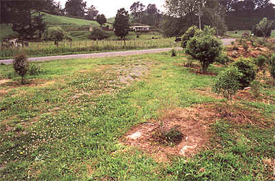
"Pumphouse" Machine Mounts |
|
|
|
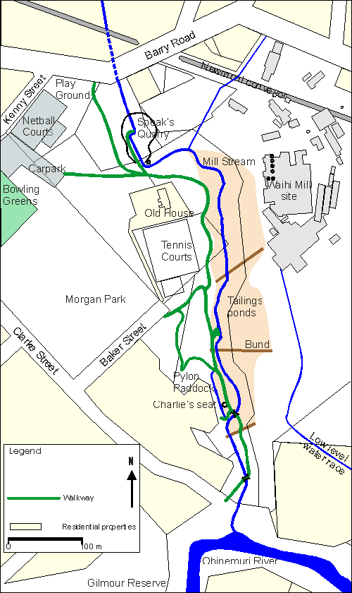
Mill Stream Walkway Historic Features
Concrete machine mounts, between Clarke Street and the Ohinemuri River, have long been a mystery. An old photograph suggests that a small building once existed at this site, and old residents talk of this area being known as the "pumphouse". A paragraph from a Ohinemuri Regional History Journal article by Oliver Pipe (Journal 11, May 1969) sheds some light on this "pumphouse": If we came home from school via the Recreation Grounds we could walk along a nine inch water pipe carried on trestles, as far as the Junction Powerhouse. After coming from the pumphouse at Worths creek to a Dam located outside the Powerhouse at the Junction, the water was used in the Boilers to generate steam or as some cooling system connected with the power generation. It would come out of the Powerhouse quite hot, and would be cooled by passing through a series of shallow ponds before flowing back into the main Dam to be used again. Some of this pumped water was also used to wash the Clinkers and ash away from the grates or firebars under the horizontal Boilers. Worth’s Creek was a swimming hole in the Ohinemuri, a little further upstream than the "pumphouse". It is where the steps have been cut into the bank on the true left bank. The Junction battery, on the side of Martha Hill was powered by electricity from coal fired steam turbines. A dam on Mill Stream was constructed beside the powerhouse, to provide boiler water and cooling water. If the flow in Mill Stream was too low to provide the necessary water (this is very likely in the summer), then supplementary water would be required. It is entirely possible that the "pumphouse" supplied this water from the Ohinemuri when required. These foundations then, would be contemporary to, or post date, the battery construction (1906), and presumably became redundant when the battery closed (maybe 1926). The pipe from the pump to the powerhouse (a distance of some 1200m) may be the responsible for the ditch which runs between the two walkway bridges. A short piece of rusty pipe (300mm or 12" dia.) and broken gibault lie near the walkway counter. The ditch makes little sense as a drainage ditch, but may have been created to lay the pipe, or to subsequently recover it when no longer in use. The 1909-10 Waihi Panorama photograph shows power poles running along the valley. They appear to originate from the Grand Junction Powerhouse but it is difficult to tell. The lines disappear behind Union Hill at the left of the photograph, so we can not see where they lead; nor can we see the site of the "pumphouse" in this photograph. These same poles can be seen in the c. 1905-6 photograph, so if they were powering the "pumphouse", they did so from the beginning of the battery. It seems quite likely that the "pumphouse" was electrically powered.
|
|
Waihi District Walkways Inc. PO Box 241 Waihi New Zealand Send e- mail to: Waihi Walkways |