|
|
|
|
Mill Water Race |
|
|
|
Mill Stream Walkway Historic FeaturesMill Stream Water Races
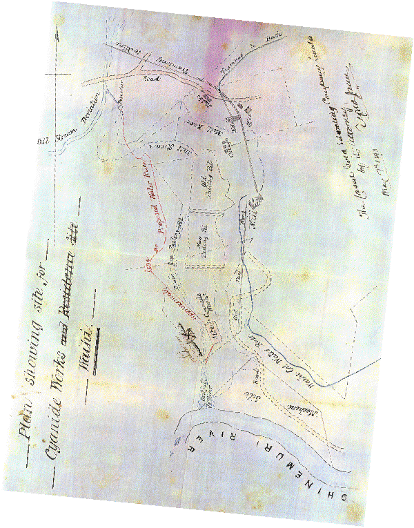
Mill Water RaceMap 1 (May 1893) The earliest water race appears to have been on the true left bank of Mill Stream. The only reference to it is on the 1893 Cassel map: Plan showing site for Cyanide Works Waihi, May 17 1893. The map shows Mill Stream (perhaps the earliest reference to this name) flowing beneath the road (unlabelled, but what we now call Barry Road). A short distance below the road was created a reservoir (presumably behind a dam), at the end of a short section of ground channel. This channel still exists, and currently discharges into Speaks Quarry. The reservoir features in many subsequent maps, and is also labelled as a dam in at least one. Mill Race is shown taking water from the reservoir to the Waihi Mill, apparently following the contour, presumably in an open ground channel. This is the only map to show this race. The Waihi Mill was built in 1888, and although it was at first steam powered, processing water would have been required. Mill Stream was virtually the only option, and this race was short, and easily created. Probably short lived, superseded by the more ambitious water races built soon after. Also shown on the map is the mysterious "Mill Stream Deviation", which also appears in many subsequent maps. It is called "Stream Diversion" in the 1894 Cassel map. Mysterious because its origins and functions are not clear. The only reference to it found so far is from the 1894 Mines Statement: Cassel’s Company's Works. — A water-race was constructed to bring in water from the creek receiving water from the swamp, and also that flowing from the adit-level of the Waihi Mine. The creek is Mill Stream (the area upstream of the road was swampy ground then), and water flowing from the adit level of the mine was mine drainage from the lowest mine entrance on Martha Hill. This water drained down to the gully where the Croquet lawns are now. Mill Stream Deviation appears to have been a ground channel, following the contour of the land, cut to intercept these waters and bring them into Mill Stream just below the road. This mine drainage was to increase enormously over time as the mine grew deeper, and water was pumped out. The volume of water contributed may conceivably have exceeded that in Mill Stream itself in time. Subsequent maps, and photographs, show this water route. The mine drainage may have followed, and added to, an existing water course draining the flank of Martha Hill, and capturing this water may have given rise to the labels: "deviation" and "diversion". The boundary lines, still part of the modern cadastral database, reflect the position of this early deviation. The fact that this diversion appears on this map as background information (the proposed water race is in red) suggests that it already existed, presumably created by the Waihi Gold Mining Company to augment the water available to the Mill. One other map shows an original course for Mill Stream, and though similar to the one shown on this map, it places the original Mill Stream between the reservoir and the diversion, which is more likely (and lines up with the road crossing). This original course indicates the low ground. Presumably the diversion, the reservoir and the mill race were in-ground features, and followed the ground contours. The map shows a proposed route for the Cassel water race which crosses the original stream gully. Though not indicated, a trestled flume or pipe must have been intended to cross this gully. Note: This map shows a proposed route for their water race, and site for the cyanide works. A later map (1894) suggests a slightly different route and site for the plant. The map also shows only two tailings pits, and a "Drain from Tailings Pit" connecting the "Old Tailing Pit" (first or upper) to the Ohinemuri River. The Machine Site shown beside the Ohinemuri appears to approximate what is later called Union Special Site No.3, the Barry residence.
|
|
Waihi District Walkways Inc. PO Box 241 Waihi New Zealand Send e- mail to: Waihi Walkways |